Nice Panorama
- News :
- French Riviera :
- Provence :
- Var :
- Leisure :
- Economy :
- Gastronomy :
- Sport :
- Accommodation :
- Tourism :
- Site Map :
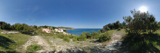
Beaches and ports of Carry-le-Rouet
Carry-le-Rouet, a village on the Blue Coast (between Marseille and Martigues) has three beautiful beaches and two ports (the beaches are not authorized to animals).
For those who prefer less crowded places, various creeks will greet you near the Big Blue (Creek of the Salty Water, Creek of Fallen Stones).
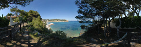
The beach of Le Rouet
The beach of Le Rouet is the main beach of Carry-le-Rouet. Located in the district of Le Rouet, it is very crowded in summer. This natural beach with sand and shingle is equipped with a first aid post in the season, showers and toilets and is accessible for people with reduced mobility.
One can find on the beach restaurants and rental mattresses and kayaks. A large paying car park, 380 places during the summer, is located in contact with the beach. It is possible to leave the car not far which is particularly interesting for families with children. Off season the parking is free (70 places)
To the east of the beach, you will find the coastal path which allows you to go to the promontory of the chapel of Our Lady of the Rouet. If you follow the coastal path and pass the holiday center, after 20 minutes of a beautiful walk, you will arrive at the Creek of the Salty Water and its shingle beach. It is also possible to see the train of the Blue Coast pass over the viaduct of the Salted Water, situated in the pine forest.
The beach of Cap Rousset
Located in the district of Barqueroute, the lovely beach of Cap Rousset was redesigned in terraces. The beach has a first-aid post in the season, showers and toilets. We can find on-site a snack glacier and a car park of around 200 places nearby.
As this beach is located in the heart of the marine reserve, it is possible to discover the underwater trail in the Marine Park of the Blue Coast.
The beach of the Tuilière
This small cove, which consists of natural shingle, is located 1 km from the city center and the port. Close to the beach of the Tuilière, one can found a private place for launching boat into the sea (the place is managed by the association “Les calanquais de la Tuilière »), a shower and toilets.
The beach is watched during the season and has free parking of 50 places and accommodation and restaurants nearby.
Sheltered Port from Le Rouet
This port, with a capacity of 100 boats, is located west of the beach of Le Rouet (Location 43 ° 20.1 N - 5 ° 10.5 E). Its small size does not allow to offer places for passengers. Protected by two breakwaters, the port is well sheltered from the Mistral, but remains subject of windward from South and Southeast.
Société Nautique du Rouet-Plage (SNRP)
Port du Rouet
13620 Carry-le-Rouet
Phone : 04 42 45 37 38
The port of Carry-le-Rouet
Carry port (Location 43 ° 19.7 N - 5 ° 09.2 E) is sheltered from winds from the West to the Northeast. Its capacity is 559 places and has 20 passenger places.
His approach is relatively easy because it is located west of the “sugar loaf” (concrete cone on a rock spur) and has a remarkable landmark in the presence of a 17 floors building visible 5 miles in clear weather.
Captaincy
East dock
Marina
13620 Carry-le-Rouet
Phone. : 04 42 45 25 13
One can also find descriptions of Carrry-le-Rouet beaches and Carry-le-Rouet creeks on the site of the Tourist Office.
Provence
Camargue
Alpilles
Pays Aixois
Luberon
Etang de Berre
La Côte Bleue